Sunday, March 26, 2017
Bright Angel Trail out-and-back to Phantom Ranch
21+ Miles, 5000+ ft. of Elevation Gain
Running R2R2R (Rim to Rim to Rim) is a bucket list item for most ultra trail runners, and it’s certainly one of ours. The stars have to align to make it happen though (at least for a newbie) – good weather (Spring or Fall), good training, and good health. We decided this past weekend to dip our toes so to speak into the Grand Canyon by doing a Rim to River run from the South Rim. The weather was expected to be great, our training has been pretty solid, but with a major race in two weeks, it didn’t make sense to do the entire R2R2R.
Stop in Sedona
This adventure started when Stephen was invited by his Flagstaff-based coach Chris Vargo to run the Canyon. I knew there was no way I could keep up with them, so I sought out some friends from TTR to join me on a separate run. The four of us drove up to Flagstaff on Saturday morning, stopping in Sedona on the way to get in a shorter run on the Hangover Trail. This trail is popular with mountain bikers and has a curious sign that describes it as a “double black diamond” mountain bike trail. I’m not surprised. We found ourselves rock climbing up the sides of the smooth but grippy red rock multiple times as mountain bikers careened down past us. Terrifying!

Signage along the Hangover Trail in Sedona cautioning hikers and bikers that it’s EXTREME!
Injured Runner Excuse (typical)
I ran 26 miles on Saturday the weekend before as my final long training run before the upcoming 100k and then PRed the 5k distance at a race the following morning (makes sense). Ever since, my right quad has been bothering me, and my usual shin/calf issues have been pretty bad. I only ran twice during the week between this and Grand Canyon – two 3-mile runs, and both felt pretty awful. Thursday night I went to physical therapy, and she scraped the heck out of both achilles (Graston technique) leaving sore bruises behind. Needless to say, this Sedona run did not feel good. I looked like a mess too wearing a compression sleeve on my thigh, compression socks, and a brace on my left ankle since I had rolled it to the point of black and blue swelling three weeks prior and the resulting stiffness causes serious pain anytime my left foot is placed at a strange angle. The Grand Canyon run was not looking too good at this point for me.


Night Before in Flagstaff
We stayed at the historic Motel DuBeau which is located right in the heart of Flagstaff, on Beaver Street and Phoenix Ave, right next door to Macy’s European Coffee House and a block south of the train tracks. I did an exhaustive search of hotels, AirBnBs, VRBOs, independent cabin rentals, etc, and this was by far the best value for a group of four and a single night. We paid $125 total for a two-room suite. The room was clean, quieter than expected (we were in the back corner away from the street), and the bed was pretty comfortable with a memory foam mattress topper. They have a wide variety of room configurations (including hostel-style dorms), so I recommend you check it out next time you’re in Flagstaff and need a cheap, convenient, place to stay that’s not sketchy.
After checking into the motel, we walked to Pizzicleta Pizza, a block to the west, for an early 5:00 dinner. Good thing we showed up early, because they open at 5:00, and there was already a line on the street for this very small place. Had we not gotten a seat, we could have gone next door to Mother Road Brewing Company where you can also order pizzas from Pizzicleta. Stephen and I have been to Pizzicleta twice before, and it’s pretty amazing artisan pizza. He had the Margherita (mozzarella and basil), and I had the Rucola (arugula and shaved parmesan). One tasty beer each from Lumberyard Brewing, and we were good for the night. Then we all returned to the hotel for post-Sedona run showers, foam rolling, stretching, and went to bed early.
Getting to the Grand Canyon
The drive from Flagstaff is about an hour and a half to Grand Canyon Village on the South Rim. We got up at 5am and were out the door at 5:45, into the sub-30 degree temperatures. We took the 180 northwest out of town and stopped in Tusayan on the outskirts of the park to grab bananas and muffins at a gas station and then paid the $30 per car entry. Parking in Grand Canyon Village itself is sparse, so we drove all the way to the end, past the Bright Angel Trailhead, and went over the train tracks towards the parking lots away from the Canyon. Fortunately we found a parallel spot just beyond the tracks where we got ready for the run, filling bottles, putting on sunscreen, going back and forth about whether or not we wanted jackets, etc. The temperature was about 34 degrees at this point at 7:15am.
Stephen and I each took a key to the car, and Ben, Laura and I headed towards the trailhead while Stephen waited to get picked up by Chris. They were going to start later than us and at the South Kaibab Trailhead to the east. As Ben, Laura, and I approached the Canyon, we saw a train of mules headed that direction and started to get an unwanted warm-up in as we rushed to beat them to the trailhead. Luckily they were just rounding up before loading up for a trip down, so we had plenty of time to use the restrooms and get pumped up to start.

Your standard photo of the start of the Bright Angel Trail from Grand Canyon Village on the South Rim
Trailhead to 1.5 Mile Rest House
There weren’t many people on the trail at 7:30am, so the first mile and a half went pretty smoothly. We were in the shade for all of it, and it was pretty cold, but I also warmed up fairly quickly. We kept the pace slow in order not to destroy our quads. Quick stop at the 1.5 mile rest house to regroup and off we went. This is about as far as most people usually go into the Canyon. I didn’t have any pain in my calves or shins at this point, most likely due to the downhill. Hallelujah!
1.5 Mile Rest House to 3 Mile Rest House
Although the trail isn’t necessarily very technical, the large steps were a bit annoying just because their spacing did not allow for great running rhythm. I started to get pretty warm before reaching the 3 mile mark and took my lightweight jacket off at this point. I was very glad it was the only extra layer I had worn since it packs into its own pocket and weighs a matter of ounces. I’m not sure how many more times it’s going to need to happen before I finally learn the lesson that you may be very very cold before a race or a long run starts, but you WILL warm up quickly, so don’t overdress!
3 Mile Rest House to Indian Garden
This section started to “flatten” out a bit, becoming more runnable just because it wasn’t so steep. I came around a corner at one point to find Ben there “shushing” me and pointing into the bushes. There was a mule deer right by the trail, eating off of a tree, and another a few feet behind her. Ben said he came around the corner, and it was ON the trail. He almost flew right into it. They sure weren’t afraid of us, as I got quite a few pictures before they ambled away.

Mule Deer by the trail and a view of the South Rim

Ben getting close to Indian Garden on the way down
Indian Garden
The first campground that you get to is called Indian Garden, and this time of year it’s also the first place where you can get water. The two rest houses have restrooms (pit toilets), but the water is only on mid-May to mid-October. Indian Garden is beautiful because it’s found in the shade of tall light green Cottonwood trees, but it was particularly beautiful today due to numerous purple trees that looked like cherry blossoms. We stopped to top off our water and use the restroom before continuing on. The trail heading out of Indian Garden was under construction, so we had to take a well-marked detour down the trail towards Plateau Point for about a hundred yards before getting back onto the Bright Angel Trail.

The campsite at Indian Garden that my friends and I stayed at in 2014 when we hiked rim to rim
Indian Garden to the River
The section after Indian Garden is pretty neat. You run along a small creek for a lot of it, and you also run under a bit of an overhanging cliff. It’s also a lot more runnable than anything to this point. Eventually, you come out into an expansive section overlooking “The Corkscrew” which is a series of steep switchbacks leading quickly down into the canyon. After completing the switchbacks, you cross over multiple small streams, all of which could be done without getting our feet wet with some creative rock hopping. About this point, we ran into Stephen and Chris coming up after having come down the South Kaibab Trail. We stopped and chatted for a bit and then continued on towards the river while they continued to climb out.

Laura coming down the Bright Angel Trail after Indian Garden
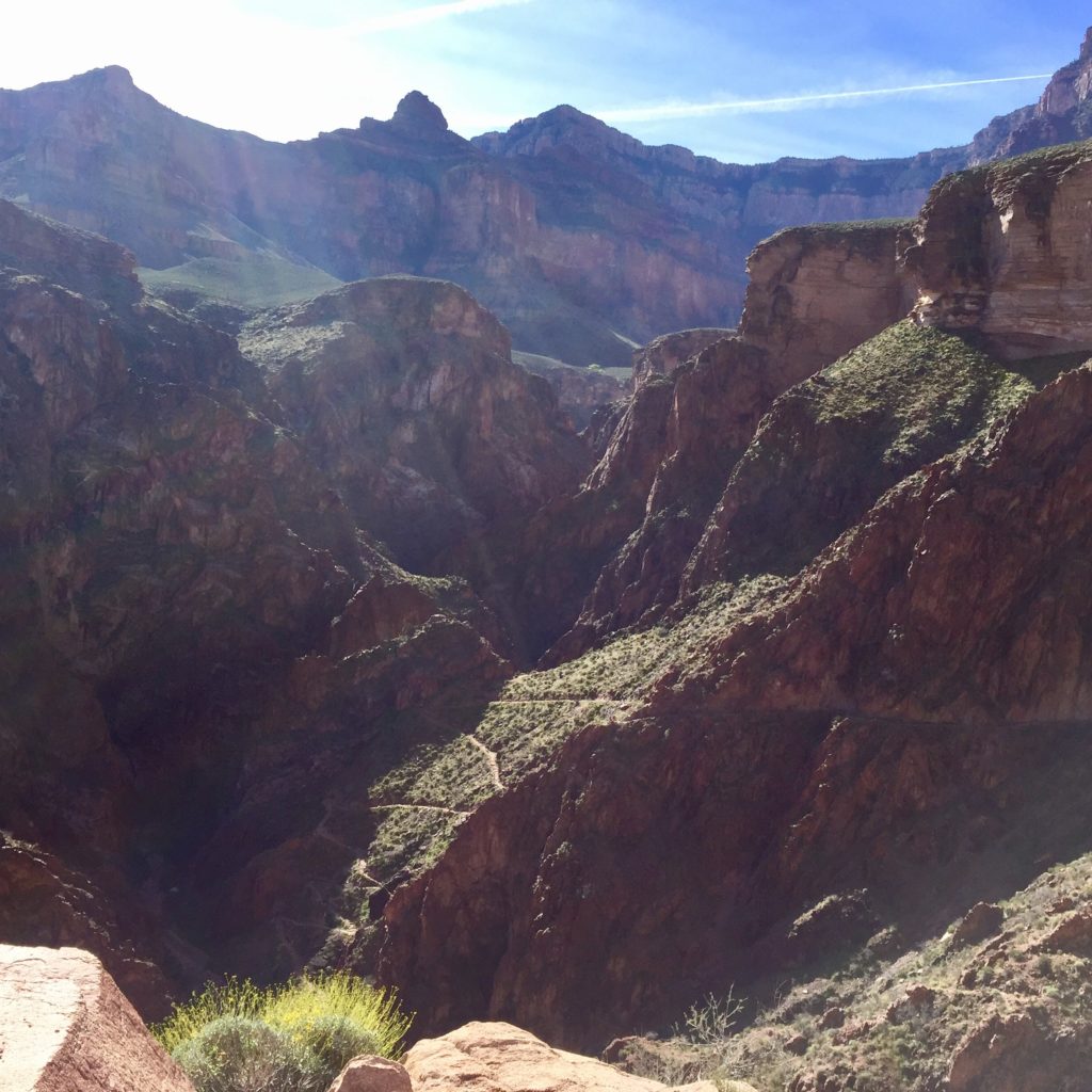
Those switchbacks down below are part of “The Corkscrew.”
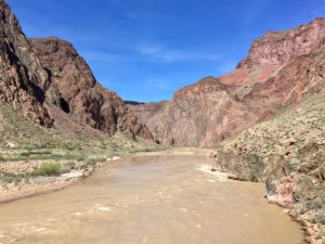
The Colorado River
As you approach the river, there’s a small spur trail on the left leading to a small beach, which we didn’t go to, and there’s also a restroom with pit toilets. Just beyond the restroom you start climbing a tiny bit as you run along the side of the cliff overlooking the muddy Colorado river. This section also has some extremely sandy sections. Eventually you get to the silver bridge which takes you across the river and then take a right towards Phantom Ranch.
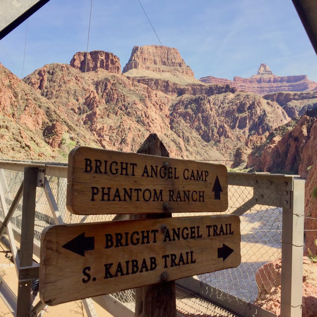
Signage is ample throughout
Phantom Ranch
Bright Angel Campground is the second campground headed this direction, and it is located along a stream less than a quarter mile before reaching Phantom Ranch. There is a REAL bathroom here, complete with functioning toilets and even an outlet. We stopped at the Canteen at Phantom Ranch, and I bought a lemonade and a 4-pack of Oreos for a total of $4. It’s not overpriced! They have all kinds of goodies – pretzels, candy bars, Clif bars, Shot Blocs, soda, etc, things hikers/runners might need – bandaids, chapstick, magical cooling towels, and you can even send a postcard that will be carried out by mules. Make sure you bring money and addresses!
After snacking while Laura wrote her postcards, I went back outside, and I found that I actually felt cold again. Running in the sun, I had been wishing I hadn’t worn long pants, but now that my body had cooled down, I realized it certainly wasn’t hot outside. We talked to a few hikers hanging out at the picnic tables outside under the trees, and then started our return trip.

The Phantom Ranch Canteen which acts as an aid station

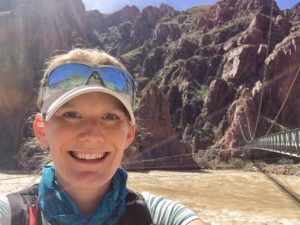
Looking back towards the river and the South Rim from Phantom Ranch
Quick “Mission” to Accomplish
For the background behind this mission, see below:

After numerous guesses from me and a ton of other people, no one got the correct answer. Then Bob gave the clue “you can hear water running,” and I immediately knew that it was the bathrooms near Phantom Ranch because of the stream right by the campground. I hiked from the North Rim to the South Rim with a group of friends over 4 days and 3 nights a few years ago, and we stayed at each of the three campgrounds in the Canyon including this one.

When I saw Bob in person last month, he told me there is no “Phantom Ranch Campground.” I looked it up and sure enough, it’s called the “Bright Angel Campground” (should have known that), so I knew on this trip that I would need to recreate this photo. After leaving Phantom Ranch, we made a slight detour to the end of the campground to get this photo…

Anyway, I didn’t win, but it was fun 🙂
Out of the Canyon
Coming out of the Canyon is as to be expected: pretty hard. My calves greatly appreciated the long downhill warm up though, and I found the climb out not to be too terrible, thanks to recent TTR runs which I would say are harder (Esperero Loop comes to mind). I refined my power hiking a bit, taking quicker shorter steps that placed less strain on my calves, and I felt that I moved a bit faster this way too. Although I didn’t feel like a trail “runner” anymore, we still were passing hikers left and right. About a half mile from the top, while zig zagging through weary casual hikers in their jeans and sandals and carrying plastic water bottles, my watch died as it tried to muster the strength to give the 21 mile beep, ugh, so I missed some important Strava segments (booo!), but I really didn’t care because the experience was so awesome, and I did it all, regardless of what Strava says 🙂 Next time, Rim to Rim to Rim!

Finishing up the Corkscrew. Although AZ is in full bloom, these were some of the only yellow flowers I saw.

One of the only mule trains we passed
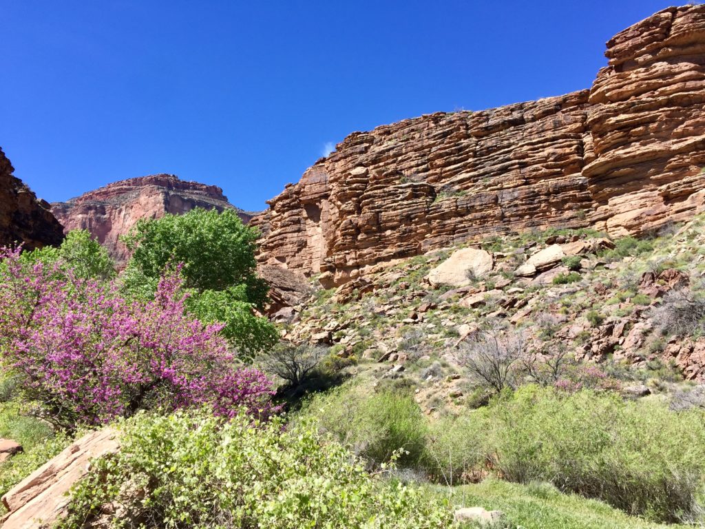
Purple trees near Indian Garden

Heading out of Indian Garden on the way up

Indian Garden temperature on the way up

Laura headed towards Indian Garden on the way up